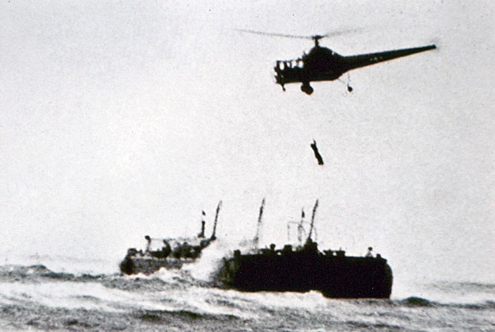
A Sikorsky YR-5A flown by Jimmy Viner with Captain Jack Beighle, hoists a crewman from Texaco Barge No. 397, aground on Penfield Reef, 29 November 1945. (Sikorsky Historical Archive)
29 November 1945: During a storm, Texaco Barge No. 397 broke loose and drifted onto Penfield Reef, approximately one mile (1.6 kilometers) off shore Fairfield, Connecticut. The storm was breaking the barge apart and the two crewmen, Captain Joseph Pawlik and Steven Penninger, were in danger.
On shore, witnesses has seen the flares fired during the night by the two seamen, but with the stormy conditions were unable to effect a rescue. Local police called the nearby Sikorsky Aircraft Corporation factory at Bloomfield, where new R-5 helicopters were being built for the U.S. Army, and asked if they could do anything.
Sikorsky’s chief test pilot Dimitry D. (“Jimmy”) Viner and the U.S. Army representative at the factory, Captain Jackson E. Beighle, U.S. Army Air Forces, took an available helicopter, flew to the scene and assessed the situation. Viner was not able to land the helicopter on the barge, so they returned to the factory where a new Army YR-5A had recently been equipped with an external rescue hoist. The R-5 was quickly prepared for flight (which involved reinstalling one of its three main rotor blades) and then Viner and Beighle flew it back to the barge.
While Viner hovered in the high winds, Captain Beighle operated the rescue hoist, lowering it to the barge where Seaman Penninger looped the leather harness under his arms. Beighle raised the harness with Penninger to the cabin but could not pull him inside. Penninger hung on to Beighle while Viner flew the helicopter to the beach.
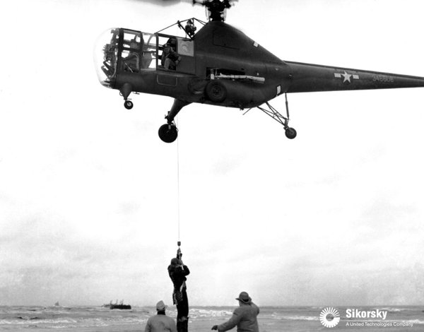
With Jimmy Viner at the controls, the Sikorsky YR-5A lowers Captain Joseph Pawlik to the sand at Fairfield Beach, Connecticut, 29 November 1945. The helicopter’s serial number is difficult to read, but it may be 43-46608. (Sikorsky Historical Archive)
After lowering Penninger to the beach, Viner took the R-5 back to the barge to pick up Captain Pawlik. When Beighle attempted to raise the hoist it jammed, leaving Pawlik suspended 30 feet (9 meters) below the helicopter. Viner again returned to the shore and carefully lowered Pawlik to the sand.
The United States Coast Guard had demonstrated the use of the rescue hoist a few months earlier, but this was the first time it had been used during an actual emergency.
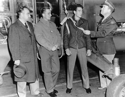
(Left to right, Dimitry D. Viner, Sikorsky chief test pilot, Captain Joseph Pawlik, Seaman Steven Penninger, rescued from Texaco Barge No. 397, and Captain Jackson E. Beighle, U.S. Army Air Forces. (Sikorsky Historical Archive)
The rescue can be seen in this YouTube video, beginning at about the 16-minute mark:
The Sikorsky YR-5A (Model S-48) was a single-engine, two-place helicopter. The cabin was built of aluminum with plexiglas windows. The fuselage was built of plastic-impregnated plywood and the tail boom was wood monocoque construction. The main rotor consisted of three fully-articulated blades built of wood spars and ribs and covered with fabric. The three bladed semi-articulated tail rotor was built of laminated wood. The main rotor turned counter-clockwise as seen from above. (The advancing blade is on the helicopter’s right.) The tail rotor was mounted on the helicopter’s left side in a pusher configuration. It turned clockwise as seen from the helicopter’s left.
YR-5A 43-46608 was one of one of twenty-six service test helicopters built between November 1944 and July 1945. There were slight changes from the earlier five XR-5A prototypes. The R-5A went into production in July 1945 and more than 300 had been built by the time production ended in 1951.
The helicopter’s fuselage was 41 feet, 7.5 inches (12.687 meters) long. The main rotor had a diameter of 48 feet (14.630 meters) and tail rotor diameter was 8 feet, 5 inches (2.2.565 meters), giving the helicopter an overall length of 57 feet, 1 inch (17.399 meters) with rotors turning. It was 13 feet, 1.5 inches (4.001 meters) high. The landing gear tread was 12 feet (3.7 meters). The R-5A had an empty weight of 3,780 pounds (1,714.6 kilograms) and maximum takeoff weight of 4,900 pounds (2,222.6 kilograms). Fuel capacity was 100 gallons (378.5 liters).
The helicopter was powered by an air-cooled, supercharged, 986.749-cubic-inch-displacement (16.170 liter) Pratt & Whitney Wasp Jr. T1B4 (R-985 AN-5) direct-drive, nine-cylinder radial engine which was placed vertically in the fuselage behind the crew compartment. This engine was rated at 450 horsepower at 2,300 r.p.m., Standard Day at Sea Level. The R-985 AN-5 was 48.00 inches (1.219 meters) long, 46.25 inches (1.175 meters) in diameter and weighed 684 pounds (310.3 kilograms) with a magnesium crankcase.
The R-5 had a maximum speed (Vne) of 107 knots (123.1 miles per hour/198.2 kilometers per hour). Range was 275 miles (442.6 kilometers). The service ceiling was 14,800 feet (4,511 meters). The absolute hover ceiling was 3,000 feet (914.4 meters).
Dimitry D. (“Jimmy”) Viner with a Sikorsky S-51, the civil version of the R-5, photographed in 1995. (Sikorsky Historical Archive)
Colonel Joseph Randall Holzapple, commanding officer, 319th Bombardment Group, Light, at Okinawa, 1945.
25–29 November 1945: Colonel Joseph Randall (“Randy”) Holzapple, U.S. Army Air Force, commanding officer of the 319th Bombardment Group, Light, departed Savannah, Georgia, as the pilot of a Douglas A-26C Invader twin-engine light attack bomber. His co-pilot on this flight was Lieutenant Colonel Charles R. Meyers. The navigator was Lieutenant Otto H. Schumaker and Corporal Howard J. Walden was the airplane’s radio operator.
The A-26 headed west, and kept heading west. 90 hours, 54 minutes later, Colonel Holzapple and his crew arrived at Washington National Airport, Washington, D.C. They had flown completely around the world, covering 24,859 miles (40,007 kilometers). The flight time was 96 hours, 50 minutes.
The A-26C Invader was built by Douglas Aircraft Company at its Long Beach, California and Tulsa, Oklahoma plants. It was 51 feet, 3 inches (15.621 meters) long with a wingspan of 70 feet, 0 inches (21.336 meters) and overall height of 18 feet, 6 inches (5.639 meters). It was designed to be flown by a single pilot, with a navigator/bombardier and a gunner. The A-26C weighed 22,690 pounds (10,292 kilograms) empty an had a maximum takeoff weight of 37,740 pounds (17,119 kilograms).
Power was supplied by two air-cooled, supercharged 2,804.4-cubic-inch-displacement (45.956 liter) Pratt & Whitney Double Wasp 2SB-G (R-2800-27) two-row, 18-cylinder radial engines with a compression ratio of 6.65:1. The R-2800-27 had a Normal Power rating of 1,600 horsepower at 2,400 r.p.m. at 5,700 feet (1,737 meters), 1,450 horsepower at 2,400 r.p.m. at 13,000 feet (3,962 meters), and 2,000 horsepower at 2,700 r.p.m for takeoff. War Emergency Power was 2,370 horsepower at 2,700 r.p.m. at Sea level. The engines turned three-bladed propellers with a diameter of 12 feet, 7 inches (3.835 meters) through a 2:1 gear reduction. The R-2800-27 was 6 feet, 3.72 inches (1.923 meters) long, 4 feet, 4.50 inches (1.334 meters) in diameter and weighed 2,300 pounds (1,043 kilograms).
The A-26 was a fast airplane for its time. It had a maximum speed of 323 knots (372 miles per hour/598 kilometers per hour) at 10,000 feet (3,048 meters). The service ceiling was 20,450 feet ( meters) and its range was 1,510 nautical miles (1,738 statute miles/2,797 kilometers) carrying a 4,000 pound (1,814 kilogram) bomb load.
Armament varied. The attack bomber could carry as much as 4,000 pounds (1,814 kilograms) of bombs in the bomb bay and 2,000 pounds (907 kilograms) on underwing hardpoints. Two Browning AN/M2 .50-caliber machine guns were mounted in upper and lower remotely-operated power turrets for defense, and as many as 14 forward-facing fixed .50-caliber machine guns were installed, with eight in the nose and three in each wing.
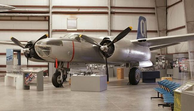
This Douglas A-26C-20-DT Invader, 43-22494, at the Pima Air And Space Museum, Tucson, Arizona, is marked as an aircraft of the 319th Bombardment Group, Light, at Okinawa, 1945. (Pima Air and Space Museum)Randall Holzapple (The 1932 Crest)
Joseph Randall Holzapple was born 7 September 1914 at Peoria, Illinois. He was the fourth of five children of Nathaniel A. Holzapple, a blacksmith, and Annetta Ritchie. He attended Pekin Junior High School, then Peoria High School, where he was a member of the French Club, Science and Math Club, and Drama Club. In his high school yearbook, Holzapple was called “refined” and “handsome.” He graduated in 1932.
In 1938, Randy Holzapple graduated from Bradley Polytechnic Institute, also in Peoria, with a bachelor of science degree in business administration. He then worked as an insurance salesman.
Joseph R. Holzapple enlisted as an aviation cadet in the Air Corps, United States Army, 31 December 1940. At the time, he was 5 feet, 8 inches (1.68 meters) tall and weighed 146 pounds (66 kilograms). He completed his flight training and on 16 August 1941, was commissioned a second lieutenant, Air Reserve.
On 25 March 1942, 2nd Lieutenant Bradley was appointed to the rank of 1st lieutenant, Army of the United States (Air Corps). Six months later, 11 September 1942, he was promoted to captain, A.U.S. (A.C.).
Captain Holzapple was assigned as operations officer of the 319th Bombardment Group (Medium), Eighth Air Force, in England. The group was equipped with the twin-engine Martin B-26 Marauder medium bomber. Operation Torch, the Allied invasion of North Africa, began on 8 November 1942, and the 319th deployed to Saint-Leu Airfield, northeast of Oran, Algeria, as an element of XII Bomber Command.
The wartime military often brought rapid advancement to qualified officers, and Holzapple was promoted to the rank of major, A.U.S. (A.C.), 5 February 1943. He took command of the 319th Group 13 August 1943, then in Tunisia. Major Holzapple was promoted to lieutenant colonel, A.U.S. (A.C.), on 13 September 1943. He was advanced to colonel, A.U.S. (A.C.), on 1 August 1944.
Lieutenant Colonel Joseph Randall Holzapple in the cockpit of a Martin B-26B-15-MA Marauder, 41-31753, circa 1943–44. (American Air Museum in Britain UPL 32425)
In November 1944, the 319th transitioned to the North American Aviation B-25 Mitchell medium bomber, but the group was returned to the continental United States in January 1945. It was then equipped with the Douglas A-26 Invader and redesignated the 319th Bombardment Group (Light).
On 1 March 1945, Colonel Holzapple married Miss Lois M. Miller in a ceremony at the Zion Evangelical Lutheran Church in Peoria. They would have two daughters, Nancy and Lynn.
The 319th redeployed to Okinawa in July 1945. It was was the first unit to be transferred from Europe to the Pacific as a complete unit.
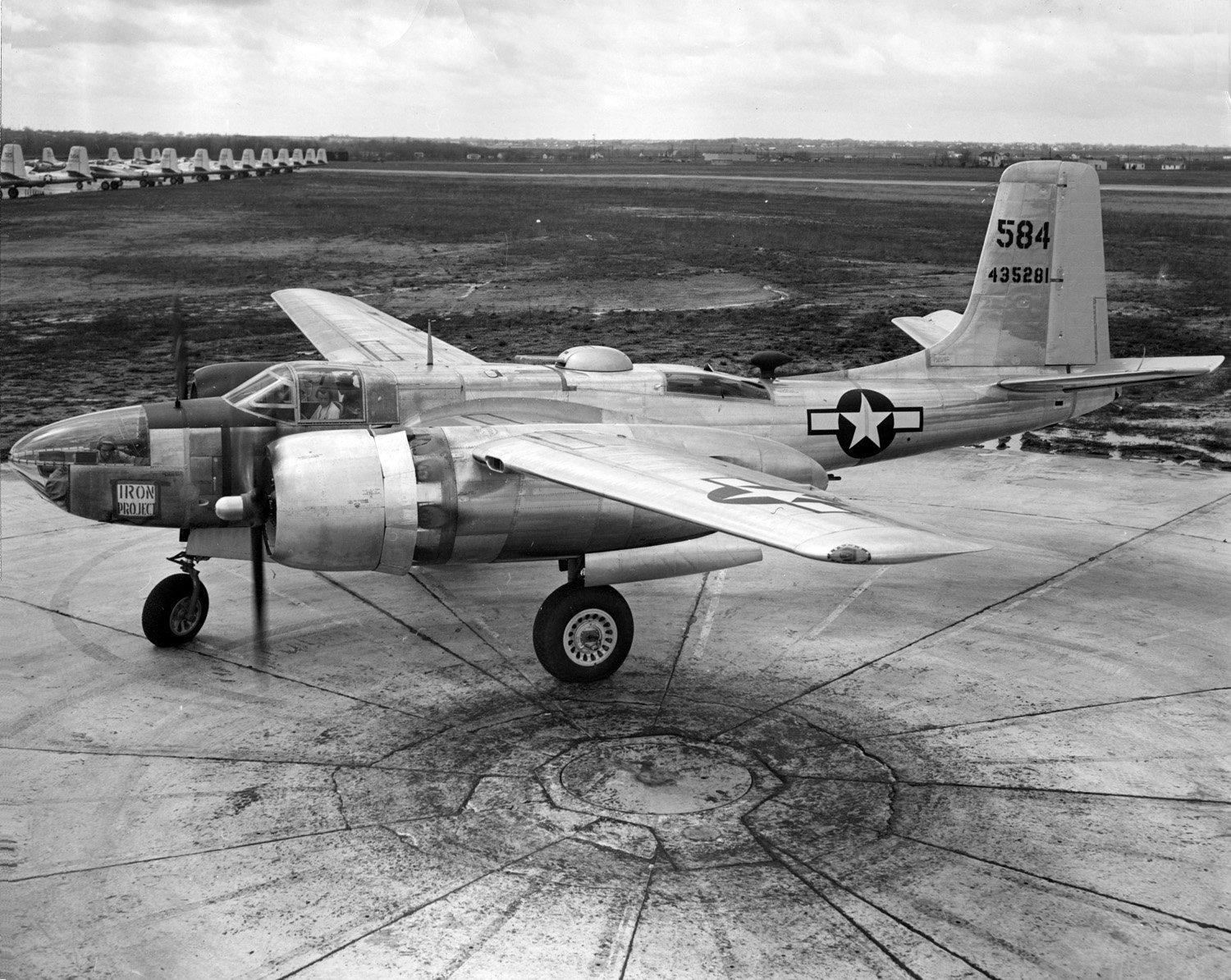
This Douglas A-26C-30-DT Invader, 44-35281, was assigned to the 319th Bombardment Group at Naha, Okinawa, 1945. (U.S. Air Force)
Colonel Holzapple flew 91 combat missions in North Africa and the Mediterannean, and another 8 over Japan and China. For his service during World War II, he was awarded teh Silver Star, the Legion of Merit, the Distinguished Flying Cross with one oak leaf cluster (a second award), and the Air Medal with 17 oak leaf clusters (18 awards). He was also awarded the British Empire’s Distinguished Flying Cross and the Croix de Guerre by France.
Colonel Holzapple remained on active duty following the war. While he continued to hold his wartime rank, his permanent rank in the Air Corps, United States Army, was advanced to 1st lieutenant, on 5 July 1946, with date of rank from 7 September 1942.
Holzapple was assigned to a number of staff positions, before being sent to the Armed Forces Staff College, 1949–50. He was next assigned to the Armed Forces Special Weapons Project, the military agency responsible for maintenance, storage, security, handling and testing of nuclear weapons. In 1954, Colonel Holzaple was appointed assistant chief of staff for Operational Readiness at the Air Research and Development Command headquarters in Baltimore, Maryland. He also attended the National War College.
In 1955 Colonel Holzapple was assiged as commanding offier of the 47th Bombardment Wing, then based at RAF Sculthorpe, near Fakenham, Norfolk, England. The group was equipped with the North American Aviation B-45 Tornado four-engine jet bomber, and the Douglas B-26 Invader. ¹
From England, Holzapple went to Germany as deputy chief of staff for operations at Headquarters, United States Air Forces in Europe. Promoted to brigadier general, in 1958 he was appointed chief of staff, USAFE.
Brigadier General Holzapple returned to the weapons systems management with ARDC at Wright-Patterson Air Force Base.
From 1969–1971, General Holzapple served as Commander in Chief, United States Air Forces Europe, based at Wiesbaden, Germany.
General Holzapple retired from the U.S. Air Force 1 September 1971.
General Holzapple collapsed and died while playing squash at The Pentagon Athletic Center, Arlington, Virginia, 14 November 1973. He was 59 years old. He was buried at the Arlington National Cemetery.
General Joseph Randall Holzapple, United States Air Force.
¹ The Martin B-26 Marauder was withdrawn from service following World War II. Most of them were scrapped. In 1948, The Douglas A-26B and A-26C Invader light bombers were then designated B-26A and B-26B.
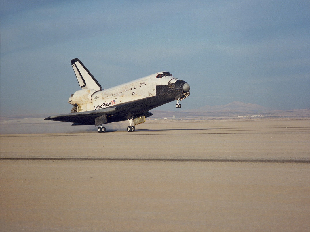
Space Shuttle Columbia (STS-9) launches from LC-39A, Kennedy Space Center, 16:00:00 UTC, 28 November 1983. (NASA)
28 November 1983, 16:00:00.84 UTC, T minus Zero: Space Shuttle Columbia (STS-9) lifted of from Launch Complex 39A, Kennedy Space Center, Cape Canaveral Florida on its sixth space flight.
On board was the largest flight crew for a manned space mission up to that time: Mission Commander John W. Young (Captain, United States Navy, Retired), Pilot; Lieutenant Colonel Brewster H. Shaw, Jr., United States Air Force; Mission Specialists Owen K. Garriott, Ph.D., and Robert A.R. Parker, Ph.D.; and Payload Specialists Ulf Dietrich Merbold, Dr. rer. nat, of the European Space Agency (ESA); and Lieutenant Colonel Byron K. Lichtenberg, D.Sc., USAF (Massachusetts Air National Guard).
The flight crew of Space Shuttle Columbia (STS-9), left to right, Owen K. Garriott, Ph.D., NASA; LCOL Byron K. Lichtenberg, D.Sc., USAF; LCOL Brewster H. Shaw, Jr., USAF; CAPT John Watts Young, USN (Ret.); Dr. Ulf D. Merbold, ESA; Robert A.R. Parker, Ph.D., NASA.
Columbia carried the NASA/ESA Spacelab module in the cargo bay. The mission was primarily to carry out 72 scientific experiments in astronomy, physics, biology, as well as to make observations of the Earth.
Columbia landed at Edwards Air Force Base, California at 23:47:24 UTC (3:47 p.m., PST), 8 December 1983. At 10 days, 7 hours, 47 minutes, 24 seconds, STS-9 was the longest space shuttle mission up to that time.
Space Shuttle Columbia (STS-9) lands at Edwards Air Force Base, California. (NASA)
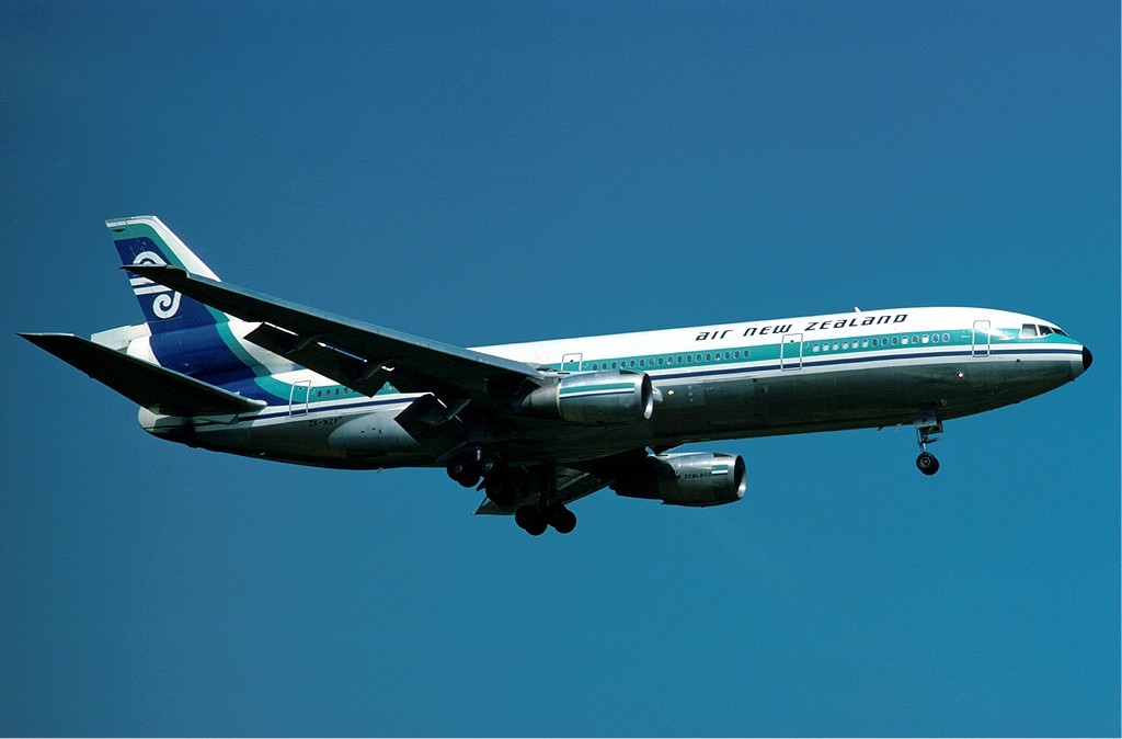
Air New Zealand McDonnell Douglas DC-10-30 ZK-NZP at London Heathrow Airport, July 1977. (Eduard Marmet via Wikipedia)
28 November 1979: An Air New Zealand sightseeing flight to Antarctica, Flight TE 901, departed Auckland Airport (AKL) on the North Island of New Zealand, at 1917 GMT, 27 November (8:17 a.m., 28 November, local time). The flight was planned to proceed to the vicinity of McMurdo Station at the south end of Ross Island, off the continent of Antarctica, and then return to Christchurch International Airport (CHC) on New Zealand’s South Island. The duration of the flight was estimated to be 11 hours and would travel a total of 5,360 miles (8,626 kilometers), all during daylight hours.
Air New Zealand had previously flown thirteen Antarctic excursions. On this date, the airliner operated as Flight TE 901 was a five year old McDonnell Douglas DC-10-30, registration ZK-NZP. On board the airliner were a flight crew of five, cabin crew of fifteen and 237 passengers.
Collins
The pilot in command (PIC) was Captain Thomas James Collins. Captain Collins held an airline transport pilot license with a DC-10 type rating. He had flown a total of 11,151 flight hours, of which 2,872 had been aboard DC-10s. Because of the flight’s planned duration, the crew included two more pilots, First Officer Gregory Mark Cassin and First Officer Graham Neville Lucas. There were also two flight engineers, Flight Engineer Gordon Barrett Brooks and Flight Engineer Nicholas John Maloney. All were very experienced pilots, type-rated in the DC-10. None, however, had previously flown the Antarctic route.
19 days before the flight, Captain Collins and First Officer Cassin had received an audio-visual briefing of the planned flight. They also flew the route in a cockpit simulator. The route of previous flights had taken the airliners from the Ross Sea into McMurdo Sound, well west of Ross Island and its 12,448 foot (3,794 meters) active volcano, Mount Erebus. At a pre-determined waypoint, the airliner turned left toward McMurdo Station. The airline’s minimum altitude through this area was 16,000 feet (4,877 meters) until south of McMurdo Station, and then only if certain weather conditions were present.
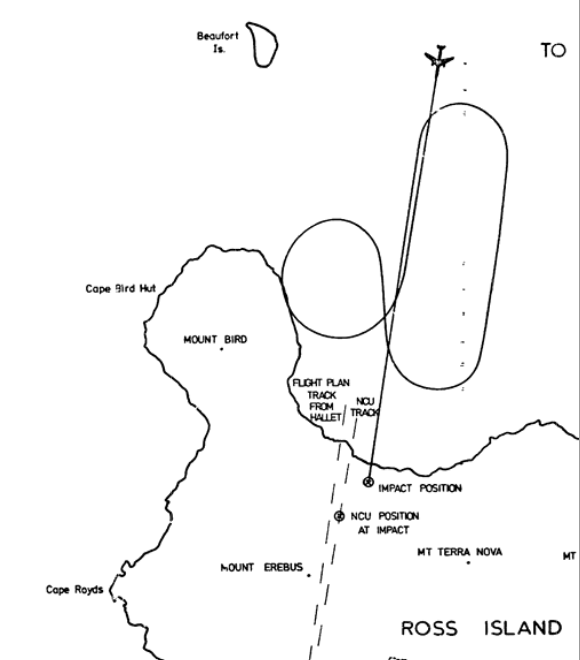
Air New Zealand flight planners had discovered that data which had been entered into the aircraft’s Area Inertial Navigation System (AINS) computer was incorrect. The coordinates of the for the destination waypoint were actually 2˚10′ west of the intended destination waypoint. The intended route was to take TE 901 directly over Mount Erebus to the emergency whiteout landing area near Williams Field (ICAO: NZWD) about 10 miles (16 kilometers) from McMurdo Station on the Ross Ice Shelf. Because of the data error, however, all previous flights had approached from well west of Ross Island before turning toward McMurdo Station at West Dailey Island. The navigation data was corrected, but the flight crew had not been informed of the change or the reason for it.
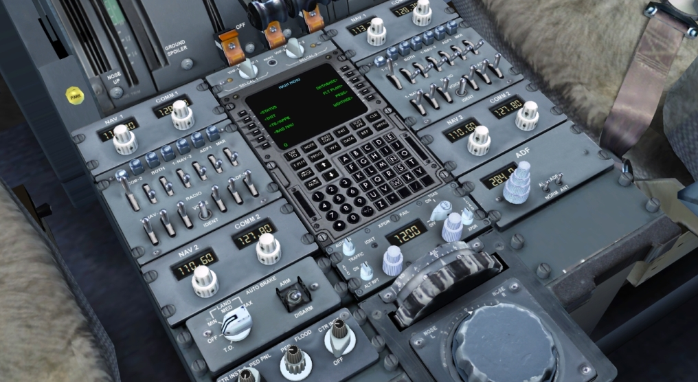
DC-10 navigation console. (Unattributed)
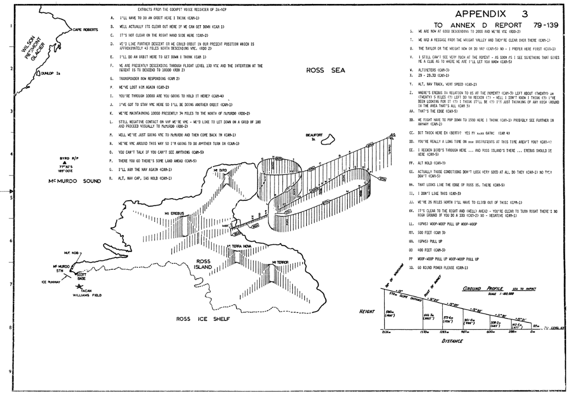
The flight toward Antarctica proceeded normally. Exactly five hours after takeoff, Captain Collins began a descent from TE 901’s cruising altitude. At this point the airliner was approximately 140 miles (225 kilometers) north of McMurdo Station. First Officer Cassin advised air traffic control, Mac Center, of their descent. The controller acknowledged and gave the current weather at McMurdo as “. . . low overcast in the area at about 2,000 feet [607 meters] and . . . some snow but our visibility is still about 40 miles [64 kilometers]. . . .” In the cockpit, Captain Collins commented that the clouds were lower than previously reported, and that, it would be, “Very hard to tell the difference between the cloud and the ice.”
First Officer Cassin requested descent to 16,000 feet (4,877 meters) but Mac Center directed the flight to “descend and maintain Flight Level 180.” (18,000 feet/5,486 meters)
Over the next six minutes, TE 901 traveled 50 miles as it descended to FL 180. Radio transmissions during the let down were unclear, with Mac Center, Flight 901 and Ice Tower all trying to make contact. It is possible that the high terrain between the airliner and McMurdo Station was blocking the signals. The pilots discussed using other frequencies. Captain Collins and Flight Engineer Brooks discussed the airliner’s present weight and the minimum speed required, which was calculated to be 252 knots.
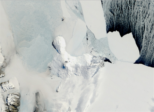
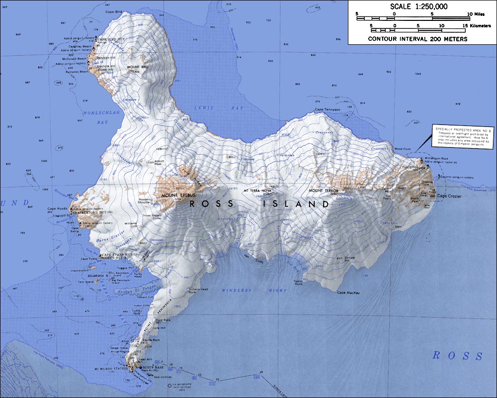
Satellite image of Ross Island. McMurdo Station is at the tip of the narrow peninsula in the lower left quadrant. (NASA)Topographic map of Ross Island, Antarctica (1:250,000 scale) (USGS)
At 00:24:44, the DC-10’s Altitude Alert sounded, indicating that the airplane had reached the assigned altitude of Flight Level 180.
At 00:31:01, Captain Collins told the crew, “I’ll have to do an orbit here I think.” Seven seconds later, he said, “Well actually it’s clear out here if we get down. . .and—” Someone in the cockpit replied, “It’s not clear on the right hand side here.” First Officer Cassin said, “No.”
Captain Collins had observed an opening in the clouds to the left of the airplane, and decided to descend further under visual conditions. He first began a descending 360˚ turn to the right, followed by a descending 180˚to the left. This put the DC-10 on a course away from McMurdo Station at 10,000 feet (3,048 meters). Captain Collins and the two flight engineers discussed the desired airspeed. With the flight still continuing outbound, at 00:42:49, Collins said, “We’re VMC [Visual Meteorological Conditions] around this way so I’m going to do another turn in.” The flight’s expert commentator, Peter Mulgrew, had entered the flight deck. Captain Collins said, “Sorry haven’t got time to talk but—” Mulgrew replied, “Ah well you can’t talk if you can’t see anything.” However, Mulgrew remained in the cockpit.
At 00:45:00, First Officer Cassin called McMurdo Center and reported, “. . . we are now at six thousand descending to two thousand and we’re VMC.”
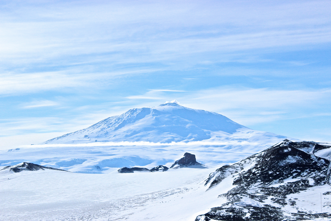
The world’s most southern active volcano, Mount Erebus on Ross Island, Antarctica, has a height of 12,448 feet (3,794 meters). (Tattered Passport)
Passing through 3,000 feet (914 meters), Flight Engineer Brooks asked, “Where’s Erebus in relation to us at the moment?” Someone answered, “Left about twenty or twenty-five miles.” Someone else asked, “Left do you reckon?” A voice said, “Well I don’t know—I think.” An unknown voice said, “I’ve been looking for it.” Cassin replied, “Yep, yep.” Brooks then said, “I’m just thinking of any high ground in the area, that’s all.”
Mulgrew replied, “I think it’ll be left, yes.” The second flight engineer, Nick Maloney, then said, “Yes, I reckon about here.” Mulgrew answered, “Yes—no, no, I don’t really know.” Then at 00:47:02, he said, “That’s the edge,” probably indicating that he could see the edge of the ice sheet ahead.
At 00:47:06, a crewmember announced, “Down to two thousand.” Both Collins and Cassin acknowledged this, “Yes.” — “Yes.” The crew then set the flight director to hold airspeed and altitude.
At 00:47:43, Captain Collins said, “We might have to pop down to fifteen hundred here I think.” Cassin replied, “Yes, OK. . . Probably see further in anyway. . . It’s not too bad. . . I see vert speed for fifteen hundred feet.”
Flight Engineer Maloney said, “—It’s not right.” An unknown voice then said, “Bit thick here eh Bert?” Maloney replied, “Yeah my. . . . oath. . . (pause) You’re really a long while on . . . instruments this time are you?” Mulgrew then said, “I reckon Bird’s through here and—Ross Island there.” Maloney answered, “Yes,” and Mulgrew continued, “Erebus should be there.” Captain Collins says, “Right.” For the next forty seconds the crew discussed radio and navigation frequencies.
At 00:49:08, Mulgrew said, “That looks like the edge of Ross Island there.” Cassin attempted to contact McMurdo Tower. At 00:49:24, Maloney said, “I don’t like this.”
At 00:49:30, Captain Collins said, “We’re twenty-six miles north we’ll have to climb out of this.” Someone answered, “OK.” Cassin told Collins, “It’s clear on the right and (well) ahead.” Collins asked, “Is it?” Mulgrew said, “Yes.” Cassin, said, “No negative.” Cassin said, “No high ground if you do a one eighty.”
At 00:49:44 the airliner’s Ground Proximity Warning System is heard: WHOOP WHOOP—PULL UP—WHOOP WHOOP
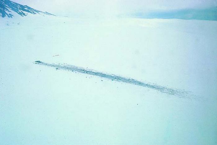
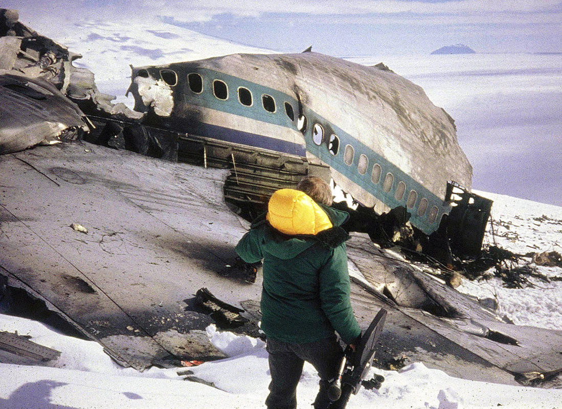
At 00:49:50 GMT, ZK-NZP struck gradually rising terrain at an elevation of 1,467 feet (447 meters) above Sea Level, while flying at 260 knots (299 miles per hour/482 kilometers per hour). The DC-10 was totally destroyed and all 257 persons on board were instantly killed by the impact. The site of the crash was on the north slope of Mount Erebus, approximately 31 miles (50 kilometers) north of McMurdo Station, at Latitude 77˚25’30” South, Longitude 167˚27’30″East.
The navigation computer showed the position of Flight 901 a few miles farther to the south and slightly left of its actual track—closer to Mount Erebus. (Transport Accident Investigation Commission)This detailed graphic shows the flight path and descent profile of Flight TE 901 and correlates CVR and FDR data to give an idea of where the airplane actually was and where the crew thought it was. (Transport Accident Investigation Commission)Looking west at the crash site of Air New Zealand Flight TE 910 at an elevation of 1,467 feet (447 meters) above Sea Level, on the north slope of Ross Island, Antarctica. Mount Erebus is at the upper left of the photograph. The terrain has a gradual upward slope of 13˚, and cross slope, right to left, of -5˚. The debris field is aligned on a heading of 190˚ True and is approximately 570 meters long. (Bureau d’Archives des Accidents d’Avions)
The intensive investigation of the accident showed that, based on the route briefing, the flight crew expected to be about 26 miles to the west. In fact, TE 901 had proceeded almost precisely along the planned track. Analysis of the navigation computer showed that its INS position was in error by just 3.1 nautical miles (3.6 miles/ 5.7 kilometers), well within its known tolerance. It was indicating almost the exact location of the flight, if anything, closer to Mount Erebus than it really was.
Much controversy ensued over who was at fault for the position error. Regardless of whether the flight was on the intended track, or on the erroneous track 25 miles west, the crew was fully aware that they were well north of McMurdo Station. Air New Zealand had established a minimum safe altitude of 16,000 feet (4,877 meters) until the flight was south of McMurdo.
3.37 Probable cause: The probable cause of this accident was the decision of the captain to continue the flight at low level toward an area of poor surface and horizon definition when the crew was not certain of their position and the subsequent inability to detect the rising terrain which intercepted the aircraft’s flight path.
—AIRCRAFT ACCIDENT REPORT No. 79-139, Transport Accident Investigation Commission (TAIC), New Zealand, Section 3.37 at Page 34.
ZK-NZP was a McDonnell Douglas DC-10-30, s/n 46910, built at the Douglas Aircraft Company’s Long Beach, California, plant during November 1974. It arrived in New Zealand 14 December 1974 for service with Air New Zealand Limited. The –30 was a long range variant of the DC-10 series. It is designed to be operated by a flight crew of three. It is 182 feet, 1 inch (55.499 meters) long with a wingspan of 165 feet, 5 inches (50.419 meters) and overall height of 58 feet, 1 inch (17.704 meters.) One of the original “wide body” jets, the cylindrical fuselage of the DC-10 has a diameter of 19 feet, 9 inches (6.020 meters).
The DC-10-30 was powered by three General Electric CF6-50C turbofan engines, rated at 51,000 pounds of thrust (226.86 kilonewtons) at Sea Level. The CF6-50 is a two-spool, high-bypass-ratio axial-flow turbofan engine. It has a single-stage fan section, with a 17-stage compressor (3 low- and 14 high-pressure stages, and a 6-stage turbine (2 high- and 4 low-pressure stages). The CF6-50C has a maximum diameter of 8 feet, 9.0 inches (2.667 meters), fan diameter of 7 feet, 2.4 inches (2.195 meters) and length of 15 feet, 8.0 inches (4.775 meters). It weighs 7,896 pounds (3,582 kilograms).
The DC-10-30 has an empty weight of 266,191 pounds (120,742 kilograms) and maximum takeoff weight of 572,000 pounds (259,455 kilograms). ZK-NZP, operating as Flight TE 901, had an “all-up weight” of 199,150 kilograms (439,051 pounds), and for the conditions of this flight, the MTOW was calculated to be 253,105 kilograms (558,001 pounds). It’s actual takeoff weight was 246,507 kilograms (543,455 pounds).
The typical cruise speed of the DC-10 is 0.82 Mach (556 miles per hour, or 895 kilometers per hour, at 30,000 feet/9,144 meters) and its service ceiling is 42,000 feet (12,802 meters). The DC-10-30 variant has a maximum range of 6,600 miles (10,622 kilometers).
At the time of the accident, ZK-NZP had flown 20,763 hours since new (TTSN).
The largest remaining fragment of McDonnell Douglas DC-10-30 ZK-NZP was this portion of the fuselage and wings. (AP Images)
Mariner 4 lifts off from LC-12, Cape Kennedy Air Force Station, 9:22 a.m. EST, 28 November 1964. (NASA)
28 November 1964, 14:22:01.309 UTC: Mariner 4, a space probe designed and built by the Jet Propulsion Laboratory (JPL), lifted off from Launch Complex 12 at the Cape Kennedy Air Force Station, Cape Kennedy, Florida. The two-stage launch vehicle consisted of an Atlas D, number 288, and an Agena D, number 6932.
The Mariner 4/Agena D separated from the first stage Atlas booster at 14:27:23 UTC. A 2 minute, 24 second burn placed the Mariner/Agena in an Earth orbit. At 15:02:53, a one minute, 35 second burn placed the vehicle into a Mars Transfer Orbit. Mariner 4 separated from the Agena D at 15:07:09 UTC. Mariner then went into cruise mode.
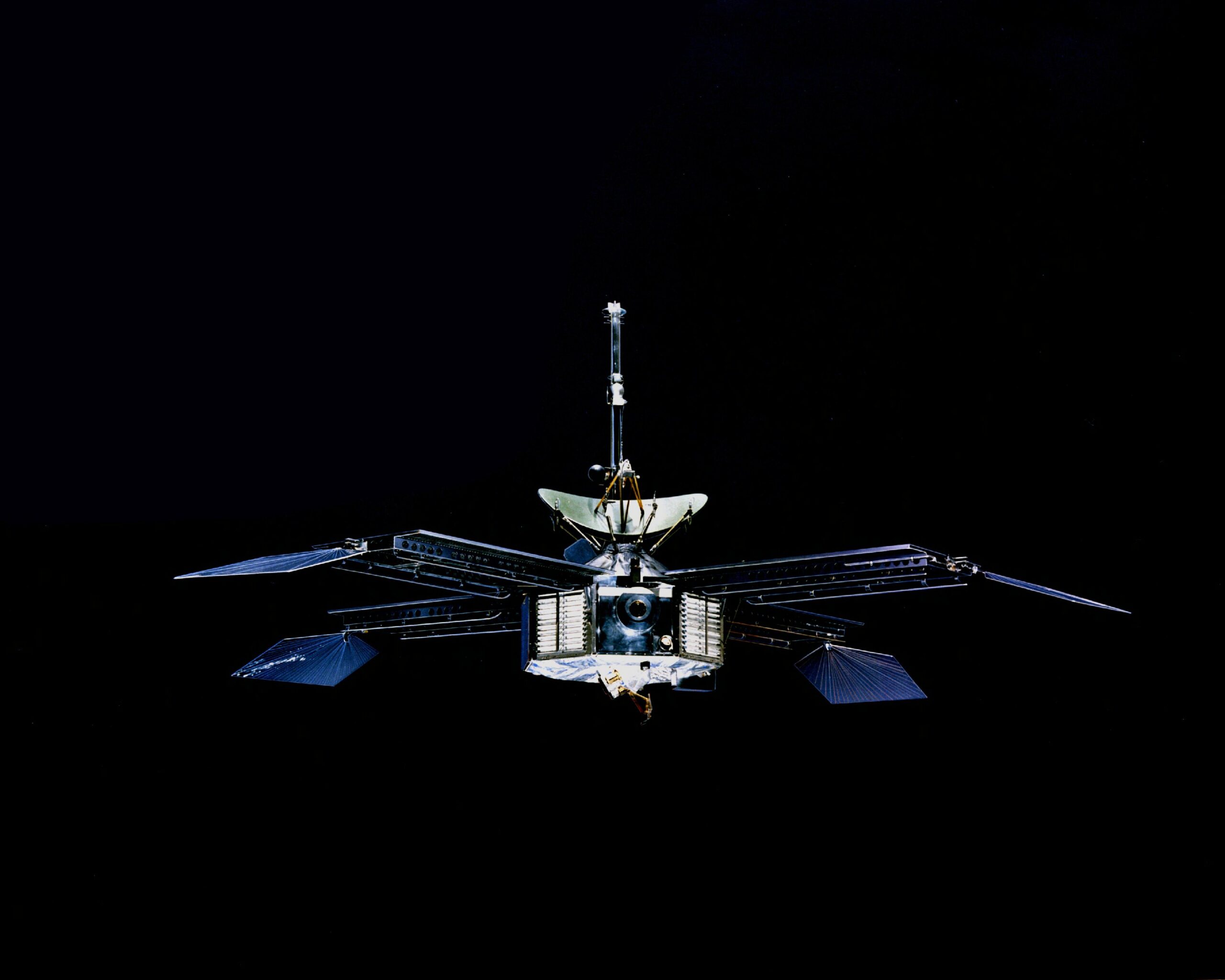
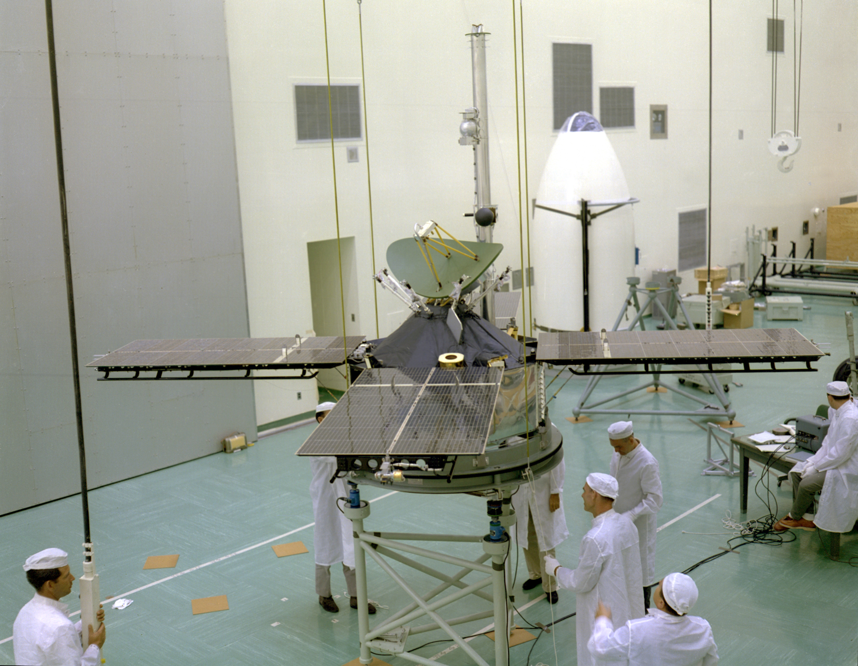
Mariner 4 (NASA)Mariner 4 during Weight Test (NASA/JPL 293_7150Bc)
The mission of Mariner 4 was to “fly by” Mars to take photographic images and gather scientific data, then relay this to tracking stations on Earth. The spacecraft carried an imaging system, cosmic dust detector, cosmic-ray telescope, magnetometer, radiation detector, solar plasma probe and an occultation experiment.
Mariner 4 overall height, including the mast, was 289 centimeters. The body of the spacecraft had a width of 127 centimeters (4 feet, 2 inches) across the diagonal, and was 45.7 centimeters (1 foot, 6 inches high. 260.8 kilograms (118.3 pounds). Power was supplied by four solar panels, each 176 centimeters (5 feet, 9.3 inches) long and 90 centimeters (2 feet, 11.4 inches) wide. The panels had 28,224 individual solar cells capable of producing 310 watts at Mars.
The rocket, a “1-½ stage” liquid-fueled Atlas LV-3, number 228, was built by the Convair Division of General Dynamics at San Diego, California. It was developed from a U.S. Air Force SM-65 Atlas D intercontinental ballistic missile, modified for use as an orbital launch vehicle.
The LV-3 was 65 feet (19.812 meters) long from the base to the adapter section, and the tank section is 10 feet (3.038 meters) in diameter. The complete Atlas-Agena D orbital launch vehicle is 93 feet (28.436 meters) tall. When ready for launch it weighed approximately 260,000 pounds (117,934 kilograms).
The Atlas’ three engines were built by the Rocketdyne Division of North American Aviation, Inc., at Canoga Park, California. Two Rocketdyne LR89-NA-5 engines and one LR105-NA-5 produced 341,140 pounds (1,517.466 kilonewtons) of thrust. The rocket was fueled by a highly-refined kerosene, RP-1, with liquid oxygen as the oxidizer.
The second stage was an Agena D, built by Lockheed Missiles and Space Systems, Sunnyvale, California. The Agena D was 20 feet, 6 inches (6.299 meters) long and had a maximum diameter of 5 feet, 0 inches (1.524 meters). The single engine was a Bell Aerosystems Company LR81-BA-11, with 16,000 pounds of thrust (71.1 kilonewtons). It was also liquid fueled, but used a hypergolic mixture of nitric acid and UDMH. This engine was capable of being restarted in orbit.
Mariner 4 made its closest approach to Mars, 9,846 kilometers (6,118 miles) on 15 July 1965. The final contact with the probe occurred on 21 December 1967.
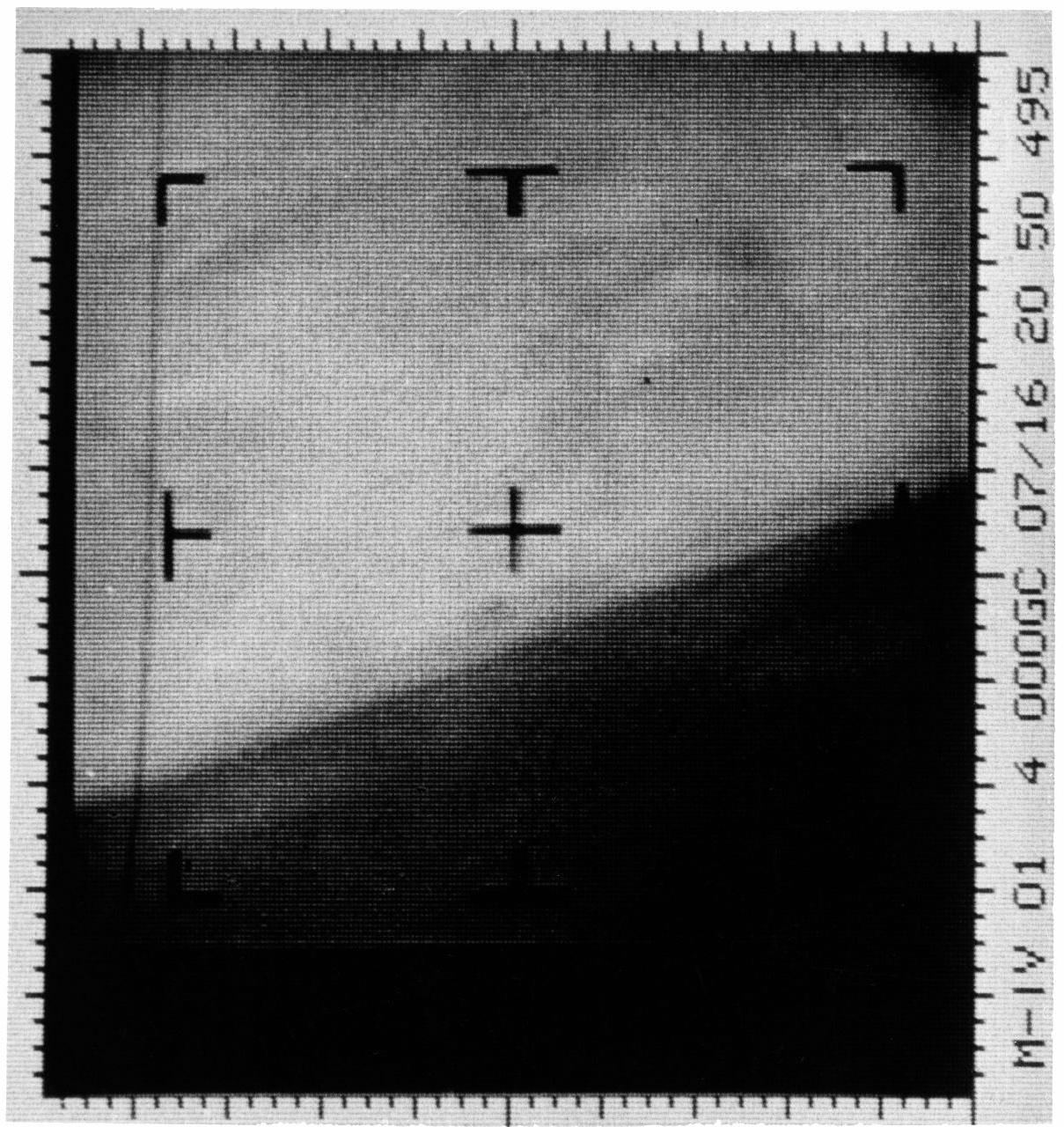
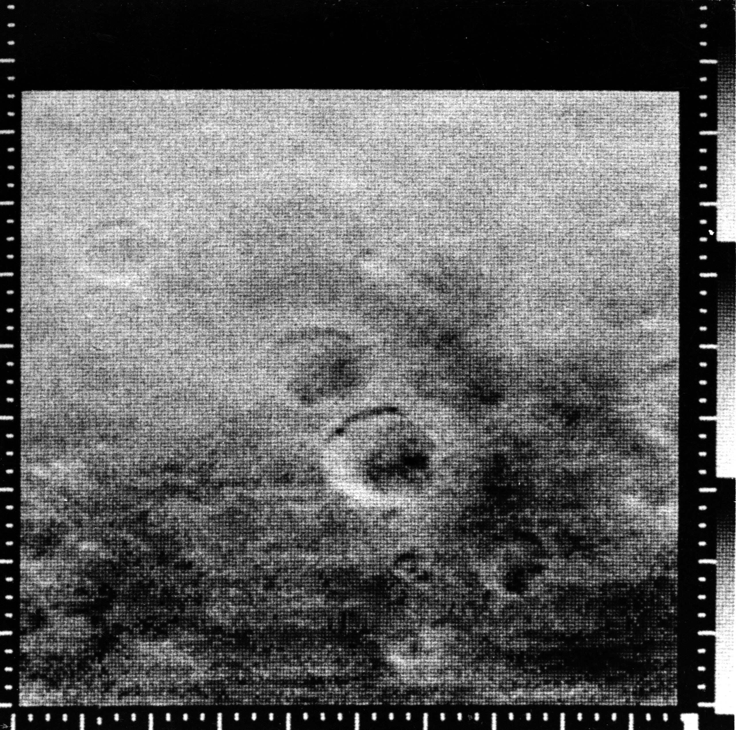
The first photographic image of Mars was captured by Mariner 4’s imaging system on 15 July 1965 and was transmitted to Earth the following day. (NASA/JPL-Caltech)Digital image of the surface of Mars, 14 July 1965. (NASA)

 The helicopter was powered by an air-cooled, supercharged, 986.749-cubic-inch-displacement (16.170 liter) Pratt & Whitney Wasp Jr. T1B4 (R-985 AN-5) direct-drive, nine-cylinder radial engine which was placed vertically in the fuselage behind the crew compartment. This engine was rated at 450 horsepower at 2,300 r.p.m., Standard Day at Sea Level. The R-985 AN-5 was 48.00 inches (1.219 meters) long, 46.25 inches (1.175 meters) in diameter and weighed 684 pounds (310.3 kilograms) with a magnesium crankcase.
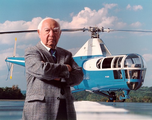
, 7th AF")

")
, General, United States Air Force. (United States Air Force 070307-F-JZ504-324)")
 launches from LC-39A, Kennedy Space Center, 16:00:00 UTC, 28 November 1983. (National Aeronautics and Space Administration Kennedy Space Center KSC-85PC-087)")

 flight crew, left to right, Owen K. Garriott, Ph.D., NASA; LCOL Byron K. Lichtenberg, D.Sc., USAF; LCOL Brewster H. Shaw, Jr., USAF; CAPT John Watts Young, USN (Ret.); Dr. Ulf D. Merbold, ESA; Robert A.R. Parker, Ph.D., NASA. (National Aeronautics and Space Administration S83-35017)")


")