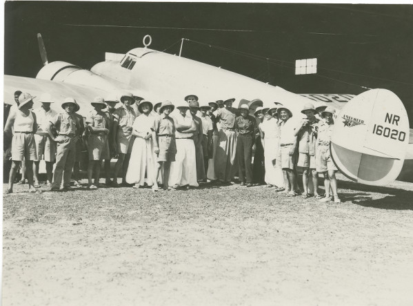
Amelia Earhart, Fred Noonan and a group of locals pose for photographs with the Electra at Assab, Eritrea, 14 June 1937. (Purdue University Libraries, Archives and Special Collections)
14 June 1937: Leg 17. From Massawa, Amelia Earhart and Fred Noonan fly their Lockheed Electra 10E, NR16020, 246 nautical miles (283 statute miles/455 kilometers) down the coast of the Red Sea to Assab, Eritrea, to prepare for the next long flight to Karachi, India. They have the aircraft serviced and fueled then await the morning.
On Tuesday, June 14, we moved down the Red Sea from Masawa to Assab to prepare for the long flight along the Arabian coast to India. Assab was nearer our objective than Masawa, offered better take-off facilities, and as well we had a greater supply of 87 Octane gasoline spotted there. Eritrea stretches along the coast of the Red Sea for 670 miles. Our course took us about half that length. Soon we left behind the mountains that bordered the coast-line and bade farewell to everything that was green. Approaching Assab the coast became terribly barren beyond description. . . .
—Amelia Earhart
Amelia Earhart’s Lockheed Electra 10E, NR16020, being serviced inside a hangar at Assab, Eritrea, 14 June 1937 (Purdue University Libraries, Archives and Special Collections)Great Circle route from Massawa to Assab, Eritrea, 246 Nautical miles (283 statute miles/455 kilometers). (Great Circle Mapper)
Bryan,
The last photo in your article “8 April 1945” about the Wee Willie is of my father’s crew. He is on the bottom row to the right wearing dark gloves. He is the navigator for this crew. 2nd Lt. Jess Ziccarello (depending on the date). I believe he has the names of the crew.
Thank you for the information. Could you ask him who the others in the photo are?
….another leg on Amelia and Fred’s journey to legend.
Here’s a link to an interactive, globe-based map tracking Earhart’s second round-the-world flight attempt:
Clicking on each leg of the flight brings up a link to the corresponding TDiA entry.
[Bryan, I know clicking on unsolicited links isn’t the safest way to spend your time, but since this interactive map is largely based on information from your site, I wanted to give you the option of reviewing it and expressing any concerns you might have about it and the way it provides links to your pages. If you do have any problems with it, I will either address them or take the map offline. As always, many thanks for all the work you put into your most excellent website.]
That is very cool! Thank you for providing the links to TDiA articles. Always looking for ways to widen the articles.

")

Bryan,
The last photo in your article “8 April 1945” about the Wee Willie is of my father’s crew. He is on the bottom row to the right wearing dark gloves. He is the navigator for this crew. 2nd Lt. Jess Ziccarello (depending on the date). I believe he has the names of the crew.
Thank you for the information. Could you ask him who the others in the photo are?
….another leg on Amelia and Fred’s journey to legend.
Here’s a link to an interactive, globe-based map tracking Earhart’s second round-the-world flight attempt:
https://lookabout.maps.arcgis.com/apps/webappviewer3d/index.html?id=6c435db8dadf41a68fdea79519b8d012
Clicking on each leg of the flight brings up a link to the corresponding TDiA entry.
[Bryan, I know clicking on unsolicited links isn’t the safest way to spend your time, but since this interactive map is largely based on information from your site, I wanted to give you the option of reviewing it and expressing any concerns you might have about it and the way it provides links to your pages. If you do have any problems with it, I will either address them or take the map offline. As always, many thanks for all the work you put into your most excellent website.]
That is very cool! Thank you for providing the links to TDiA articles. Always looking for ways to widen the articles.